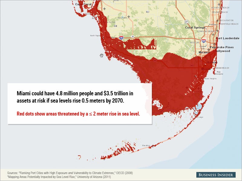
Miami could have 4.8 million people and $3.5 trillion in assets at risk in a major storm if sea levels rise 0.5 meters by 2070, according to a 2008 report from the OECD. The city will face regular and worsening flood and storm damage going forward, and eventually could become an "American Atlantis," Rolling Stone reported last year.
Read more: http://www.businessinsider.com/map-of-miami-when-sea-levels-rise-2014-4#ixzz30VCLaS1b | This Map Shows How Screwed Miami Is If Sea Levels Keep Rising
GUS LUBIN
APR. 23, 2014, 3:24 PM 3,678 20
At a special Senate hearing Tuesday in Miami Beach, Senator Bill Nelson described south Florida as "ground zero" for climate change and its threat to coastal communities, calling for "new, innovative kinds of solutions" and warning that they won't be cheap.
The coming crisis is hard to understate.
Miami could have 4.8 million people and $3.5 trillion in assets at risk in a major storm if sea levels rise 0.5 meters by 2070, according to a 2008 report from the OECD. The city will face regular and worsening flood and storm damage going forward, and eventually could become an "American Atlantis," Rolling Stone reported last year.
The threat is all but imminent as experts predict sea levels will rise about one meter by 2100.
Using a tool from the University of Arizona, we prepared a map showing the parts of south Florida that would be at risk if sea levels rose up to 2 meters (which could happen if sea levels keep rising and there is a major storm):
Read more: http://www.businessinsider.com/map-of-miami-when-sea-levels-rise-2014-4#ixzz30VBwM1ag
|